Much news is made about the changes to come to coastal landscapes from sea level rise, but there is less talk about what is already happening.
I recently published a paper that looked into the recent past to understand how coastal forests along the Delaware Bay are responding to sea level rise.
Although the bulk of the project entailed spending time in front of a computer comparing aerial photos from the 1930’s to the present, I needed to get out on the water to measure salinity along tidal streams and to ground-truth what I was seeing on aerial photos.
These field visits revealed that change is here. For example, the salinity measurements we took revealed that a 1986 map of “head of tide” locations for the tidal streams we visited had moved upstream considerably. A head of tide is the point where a stream no longer experiences tidal fluctuations. Typically there is a reach of tidal freshwater before arriving at the head of tide. We found brackish water well above these head of tide points.
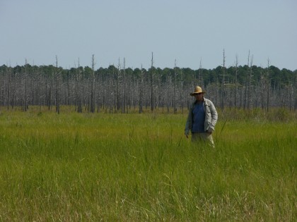
It became clear after visiting numerous small coastal streams that change is a present-tense phenomenon. Before our eyes we were seeing forests, tree by tree, succumb to the effects of increasing salinity.
Even without salinity measurements, vegetation tells the tale of change as salt tolerant vegetation mingles with and supplants the freshwater swamp plants that previously owned the terrain.
One of the most surprising discoveries we made was that a large artificial body of water, a by-product of sandmining, was now brackish. These deep ponds form when miners excavate sand and groundwater fills the hole they made. This pond drained into swampy woods which then drained into a tidal stream.
The tides now surge through those dying woods and into this large pond. I can’t imagine what the future holds for this novel aquatic ecosystem. I have already heard from some locals that the crabbing is great there!